![]()
![]()
Sand and dust storms are extreme and rapidly evolving meteorological phenomena that generate significant amounts of mineral particles in the atmosphere. They play a significant role in different aspects of weather, climate and atmospheric chemistry and represent a serious hazard for life, health, property, environment and economy.
The objective of the DUST2MSG project is to derive an hourly dust product from the Meteosat Zero Degree Service and Indian Ocean Data Coverage area with the latest version of the CISAR algorithm capable of retrieving aerosol and cloud properties over any types of surface. Retrieval of high aerosol load from space observation is challenging as is can easily be erroneous flagged as clouds. The CISAR algorithm (Govaerts and Luffarelli, 2018; Luffarelli and Govaerts, 2019) has been extended to the retrieval of cloud optical properties to overcome the need of an external cloud mask. After a so-called training period, the CISAR algorithm process all available satellite observations, i.e. both cloudy and cloud free sky. This algorithm has already been successfully applied for the joint retrieval of surface, aerosol and cloud properties over any types of surface from SEVIRI, SLSTR and PROBA-V data.
Govaerts, Y. and Luffarelli, M. (2018) “Joint retrieval of surface reflectance and aerosol properties with continuous variations of the state variables in the solution space: Part 1: theoretical concept”, Atmospheric Measurement Techniques, 11, no. 12, 6589–6603.
Luffarelli, M. and Y. Govaerts. (2019). “Joint Retrieval of Surface Reflectance and Aerosol Properties with Continuous Variation of the State Variables in the Solution Space – Part 2: Application to Geostationary and Polar-Orbiting Satellite Observations.” Atmospheric Measurement Techniques 12 (2): 791–809.
Luffarelli, M., Govaerts, Y. and Franceschini, L. (2022). “Aerosol Optical Thickness Retrieval in Presence of Cloud: Application to S3A/SLSTR Observations” Atmosphere 13, no. 5: 691.
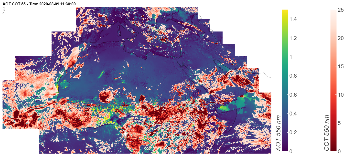
In the framework of the DUST2MSG project, geostationary observations from SEVIRI on board MSG1 (Indian Ocean Data Coverage – IODC) and MSG4 (0 degrees) are combined to address the issues associated to the decreased information content. SEVIRI observations acquired over a portion of the common area including Central and North Africa, Southern Europe and the Arabia peninsula have been processed with the CISAR algorithm to provide an hourly product of combined aerosol and cloud properties. Figure 1 shows an example of CISAR combined product of aerosol optical thickness (AOT) and cloud optical thickness (COT) over the processed portion of the common area between MSG1 and MSG4 during August 9th, 2020. These quantities are also own as AOD or COD (aerosol/cloud optical depth). The unique feature of the CISAR algorithm to process all skies, leads the a smooth continuity between the aerosol and cloud products, with the aerosol retrieval extending to the vicinity and within thin clouds.
CISAR combined product has been evaluated against ground-based observation (AERONET) over available stations located in the processed portion of the common area, showing a root mean square error (RMSE) equal to 0.12, a correlation of 0.72 and a percentage of points satisfying the Global Climate Observing System (GCOS) threshold requirements of 75.78%. These results represent a huge improvement with respect to Luffarelli et al., 2019.
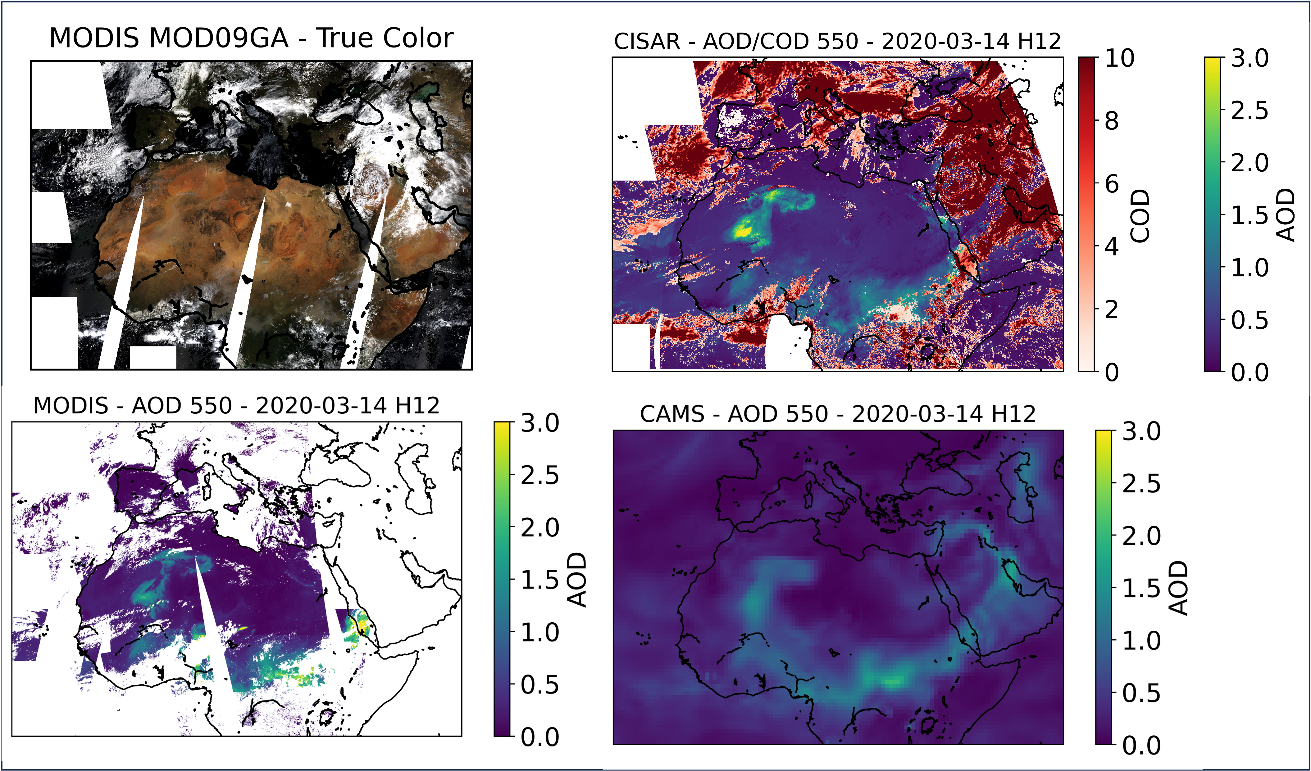
The products obtained in the framework of the DUST2MSG project have also been evaluated against other-sensor products, such as MODIS MCD19A2, and model simulations obtained in the framework of the Copernicus Atmospheric Monitoring Service (CAMS). The results of this evaluation are shown in the figure below, which shows good agreement in terms of spatial distribution of aerosols among all datasets. In the Sahara and Sahel regions dust events can be observed in the three datasets. The presence of clouds in a large portion of the image, visible in the RGB image obtained from MODIS MOD09GA observations, highlights the increased aerosol spatial coverage obtained with the CISAR algorithm compared to MODIS, both over land and water; this is thanks to CISAR’s capabilities of processing all-skies and retrieving aerosols and clouds within the same pixel.
Such combined product could be exploited in aerosol-cloud interactions studies, providing simultanoues measurements of aerosos and clouds in the area between pure clear sky and pure cloudy sky. Thanks to the innovative CISAR AOD/COD combined product it is in fact possible to observe, for instance, the first indirect effect on liquid clouds from satellite observations. For this demonstration study, one month of data (May 2020) over Europe is considered. To observe the first indirect aerosol effect on cloud, the CISAR retrieval is filtered to only consider water clouds. These clouds are expected to be lower in the atmosphere than the ice clouds and therefore interact more likely with aerosols. The mean cloud radius is calculated as a weighted mean of the radius of each cloud vertex in the CISAR solution space, weighted by the retrieved OD associated to each vertex (similarly to Eq. 2 in Luffarelli et al. 2022). The relationship between the retrieved average water cloud radius and the FM AOD retrieved by CISAR from SEVIRI observations in the VIS0.6 band is shown in the Figure 3. As expected, it can be seen that the cloud droplets’ size decreases as the aerosol load associated to fine particles increases.
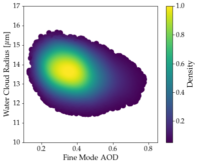
These results are extremely encouraging as, although obtained from a limited dataset and the simple characterisation of the at- mospheric solution space (Govaerts and Luffarelli 2018, Luffarelli and Govaerts 2019), show that CISAR retrieves correctly the changes in both aerosol and cloud particles in cloudy environments.
The products are available on the Zenodo repository. For any questions please feel free to reach out through the form below.
In June 2020 an extremely thick dust plume, named Godzilla, moved from the Sahara region to the Caribbeans. The Western African coast where the dust storms originates is observed by both MSG1 and MSG4. The videos below show the CISAR combined AOT/COT retrieval over the region of interest compared to CAMS dataset during the same time window. It can be seen that the thick dust storm is correctly retrieved by CISAR, following its spatial and temporal evaluation.
The first progress meeting took place online (via Microsoft Teams) on the 20/10/2022. The added value of combining two geostationary satellites with different viewing geometry is assessed by analysing the information content associated to the aerosols by means of the Jacobian, i.e. the partial derivative of the signal with respect to the state variable. The observations acquisition thus aims at maximising the associated information content. The CISAR algorihtm has been updated to process data acquired by SEVIRI on-board MSG1 and MSG4. First results in the common area are shown in the animation below over the Nile delta region.
The DUST2MSG kick-off meeting took place online (via Microsoft Teams) on the 30/11/2021.
![]()
Rayference has been created in 2013 as a private business company (SME) by Yves Govaerts and provides advanced technical and scientific expertise on Earth Observation, more specifically in the area of radiative transfer, inverse modelling, vicarious calibration and fundamental and thematic climate data record generation. Rayference contributes to the preparation of new space missions in the area of air quality and global surface monitoring. It is also involved in climate monitoring research projects and the design of algorithms for the operational retrieval of geophysical products. Rayference is a member of the CEOS IVOS working group.
Rayference project activities include: